


Settler Properties and Muskoka Wood Manufacturing
The lots on the east shore of Bella Lake were owned by Edgar Joseph Brooks and Joseph Melanthon Hill and his wife Annie Hill as Lots 18 and 19, Concession B and Lot 1, Concession 8. Edgar Brooks and Joseph Hill, a son of the Rev. Robert Norton Hill, had other properties in Sinclair Township and intended to use these properties for lumbering. Edgar Brooks also had separate properties on Rebecca Lake.
These properties were transferred to Muskoka Wood Manufacturing Company in 1918. Later they were transferred to another Hutcheson company and then to a company owned by (Bob) W. Robert Hutcheson in 1964. These were parts of lands that were owned by companies that were started by R. J. Hutcheson, who had accumulated 100,000 acres of land and the licence to operate on several townships in Algonquin Park. Most of these lands were accumulated because the people that owned them found it difficult to farm and needed to move elsewhere to make a living. The company policy on any lands that were owned by company was that no timber was to be cut that would destroy the vision of the treeline as viewed from the lakes. This was an attempt to try not to spoil the look of the land that the original settlers saw.
 |
||
|
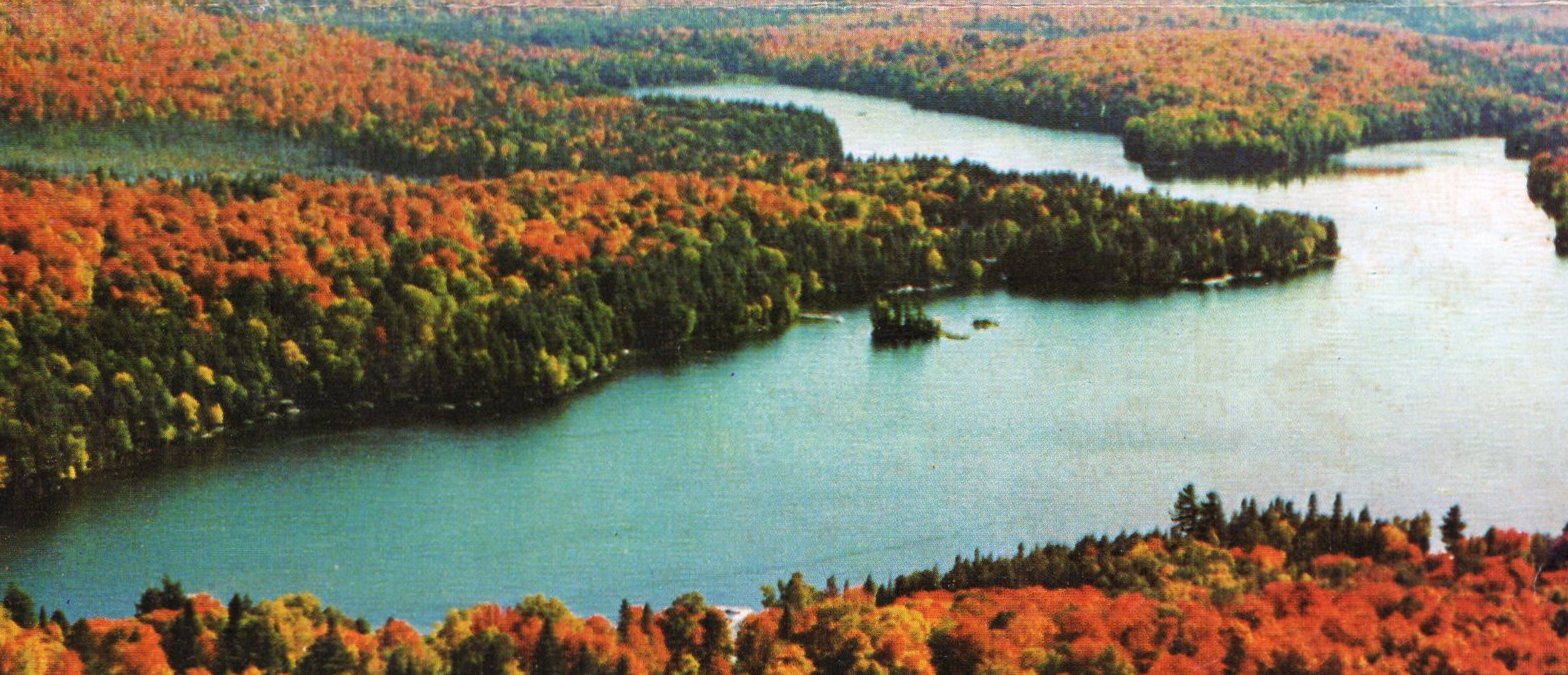
An autumn view of Swain’s Bay and the eastern shore of Bella Lake, ca. 1978. Company policy of the Muskoka Wood Manufacturing Company and subsequent restrictions on development put in place by Bob Hutcheson when he created cottage lots preserved the appearance of the shoreline. (Billie Bear Brochure Archive) |
Bella Shores Cottages
When Bob Hutcheson divided the shoreline on Bella Shores, he put in restrictions on the land so that people would build cottages that blended into the landscape. There were also restrictions about cutting down trees in front of the buildings to protect run-off and to keep the shoreline looking natural. These restrictions only lasted for about 50 years. The restrictions included a colour code restriction, which cannot be controlled today by township regulations. This was in the days before there was any zoning control by Lake of Bays. Bob Hutcheson won an award from the Muskoka Heritage Association for trying to keep the landscape in its original shape while making use of the property in a way that gave people an opportunity to have a home on beautiful Bella Lake.
When the survey for this land was done there were 24 lots. It was realized that these lots were very small, and yet people were not willing to pay for bigger lots in those days. A plan was set out where only every other lot would be sold to purchasers. The purchasers were told that the vacant lot next to them would be held and that they would be offered their adjacent lot at a similar price for the next three years. The spare lot would be offered to them with satisfactory payment terms. People realized after a few years that they really needed that bigger frontage. The zoning today covers the fact that lots should have approximately 400 feet of frontage on a lake the size of Bella Lake.
Many of the original cottages along the shore were built strictly as summer cottages and then later sometimes lined and insulated. Louis Green was the builder of most of these places and started building for Bob Hutcheson, who was building for Dick and Eloise Montanus.
Sources of a Few Names…
The history of this shoreline might have been different had Duncan Jackson not died suddenly in the spring of 1915. He and his wife, the former Mabel Hart, had planned to build a home on the mainland property opposite Betty’s Island, but this was not to be. Mabel remarried in 1919, and in 1921 her daughter Betty was christened on the island that we now know as Betty’s Island. Mabel Hart’s father owned Lot 20, Concession B, which is where Billie Bear is today.
Betty’s Island is owned by the government and is cared for by the Bella-Rebecca Community Association. We had a fire on the island in about 2014. Since that time we have tried to maintain a sign stating no fires allowed.
Leatherwood Trail was along the shore from Billie Bear to Breakfast Point, which is at the narrows of Swain’s Bay. For many years this trail was used by naturalists who spotted a great variety of birds along the shore. The name Leatherwood comes from a plant which has a yellowish flower in April and May, and its Latin name is Dirca palustris.
The point across Swain’s Bay from Breakfast Point is sometimes called Goldenrod Point. It has also been called Sunset Point, which seems to be a more likely name, as people come out around the point from Swain’s Bay to see the sunset.
East Side of Swain’s Bay
From Breakfast Point to the south end of Swain’s Bay, the property was owned by Joseph Melanthon Hill, who owned Lot 1 concession 7. (Of note is that members of the family spell the second name of Mr. Hill in different ways.) William Swain owned Lots 13,14,15,16, and 17 in Concession B, Township of Sinclair.
Mr. Swain had a brother-in-law whose name was Mr. William Nelson, who owned Lots 3 and 4, Concession 4 of Sinclair. When the Mizpah cemetery was put in, road inspector D. M. Card was responsible for planning the road from Field’s Corner going out to the Bobcaygeon Road, now a portion of Muskoka Road 8. Mr. Swain and Mr. Nelson claimed that the route deviation proposed by Card would ruin their farms and objected strenuously, as it meant that earning a living on this property would be too difficult.
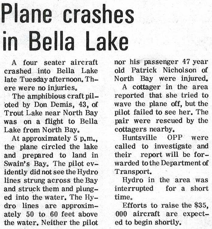
The property on the east side of Swain’s Bay is now owned by Hutcheson Forest Industries. On August 5, 2017, a tornado went through Swain’s Bay after crossing Mansell’s property on Rebecca Lake and the west side of Swain’s Bay and carried on across to Dotty Lake.Plane Crash in Bella Lake
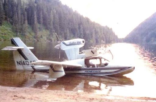
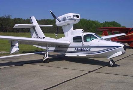
There once was a hydro wire that was strung in the air from Breakfast Point to Sunset Point about 40 or 50 feet above the water. Late one afternoon in 1972, a Lake 4 Amphibian plane was coming in over Swain’s Bay from the east end to the main part of the Bella Lake. The pilot, Don Demis of Trout Lake near North Bay, was blinded by the sun and did not notice the wire he hit, which got tangled up in the propeller, and the plane crashed.
 |
 |
|
| The Lake 4 aircraft that hit the hydro wire was similar to the ones shown here. (Bob Hutcheson) |
Bob Hutcheson was sitting on his dock and saw it happen, so rushed out in his 25 hp outboard boat, tied a rope onto the plane, and rescued the pilot and his one passenger, Patrick Nicolson of North Bay, who could not swim. As the plane started to sink, it nearly sunk Bob’s boat, which was tied with several ropes to the plane, but we had an axe on board and we were able to cut the ropes joining the two as the plane sank to the bottom.
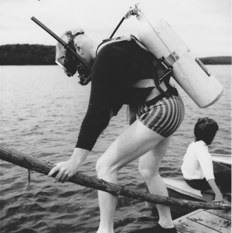
The cottagers on the lake got together and assembled equipment on a barge belonging to Bill Burgess. We set one 45-gallon oil barrel on each side of the barge and put a constructed 8-inch by 8-inch beam across between the barrels. Ron Clifford had scuba diving equipment and volunteered to do all the underwater work.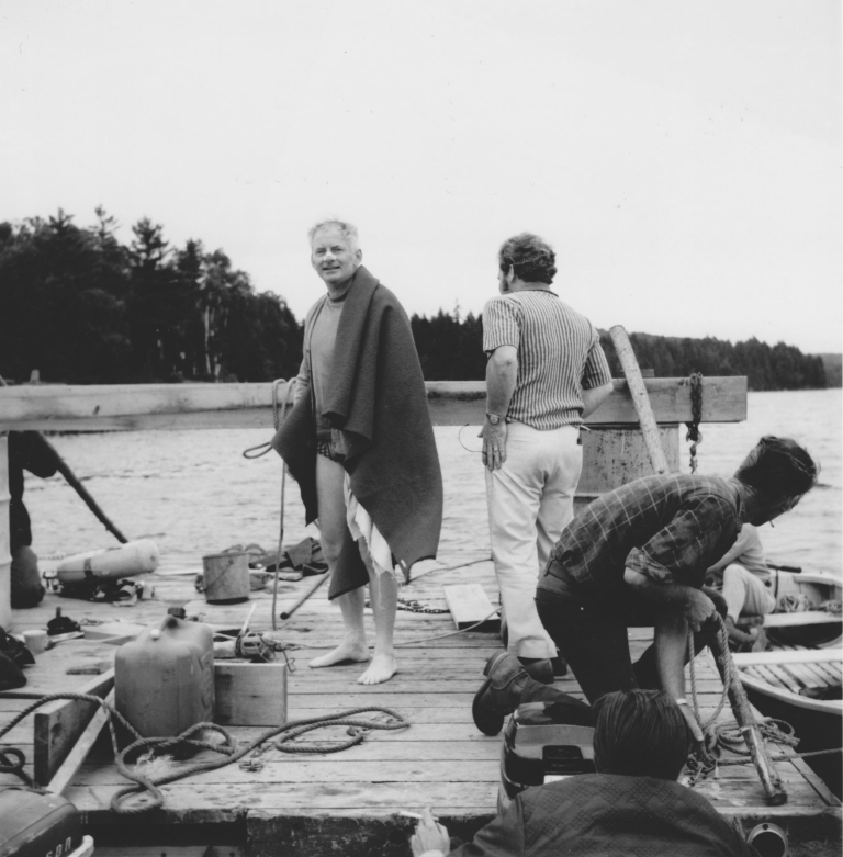 |
 |
|
| Ron Clifford standing in his bathing suit after attaching the plane to Bill Burgess’s barge (Margaret Thompson Clifford photo) | Ron Clifford preparing for another dive (Margaret Thompson Clifford photo) |
At that time, which was early in scuba diving, Ron had his own compressor, to which his wife Margaret would take his tanks and refill them, as he was needed to check out the plane many times. When Ron first dove down to the plane, he discovered that the plane had turned upside down. He had to lower the landing gear, which meant that it now stuck upwards. He attached a rope to the landing gear, and the plane was raised to just below the surface of the water. The other end of the rope went through a hole cut in the centre of the barge and was connected to the beam on top of the oil barrels. The plane was slowly floated across Bella Lake towards the Perry family beach.
It took us about two days to get the plane across the lake, as we were afraid that fast motion would pull the wings or the engine mount off the aircraft while under water. The reason that the plane was taken so far across the lake was that the Perry beach was the best beach area close to a road to be able to load the craft onto a truck.
 |
 |
|
|
The crash was reported in the Huntsville Forester, August 17, 1972. |
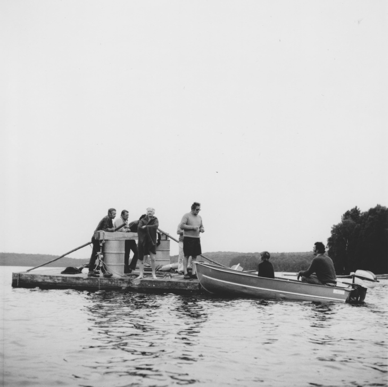
Cottagers visit as others on Bill Burgess’s barge slowly drag the plane to the Perry beach. (Margaret Thompson Clifford photo) |
The barge was manned by many volunteers of Rebecca and Bella Lakes, as we continued the operation non-stop overnight until the plane arrived on the Perry beach. When it was pulled up, it discharged some oil on their beach. Nearly everyone on the lakes came to visit the raft on its slow journey. It seemed like a festive time as we were bonding to do Good Samaritan work. Colonel Perry was very gracious about the oil spilled on his beach and the mess that was made retrieving the plane.
 |
 |
|
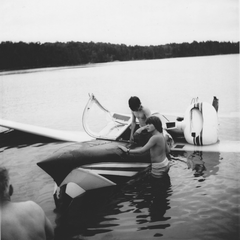
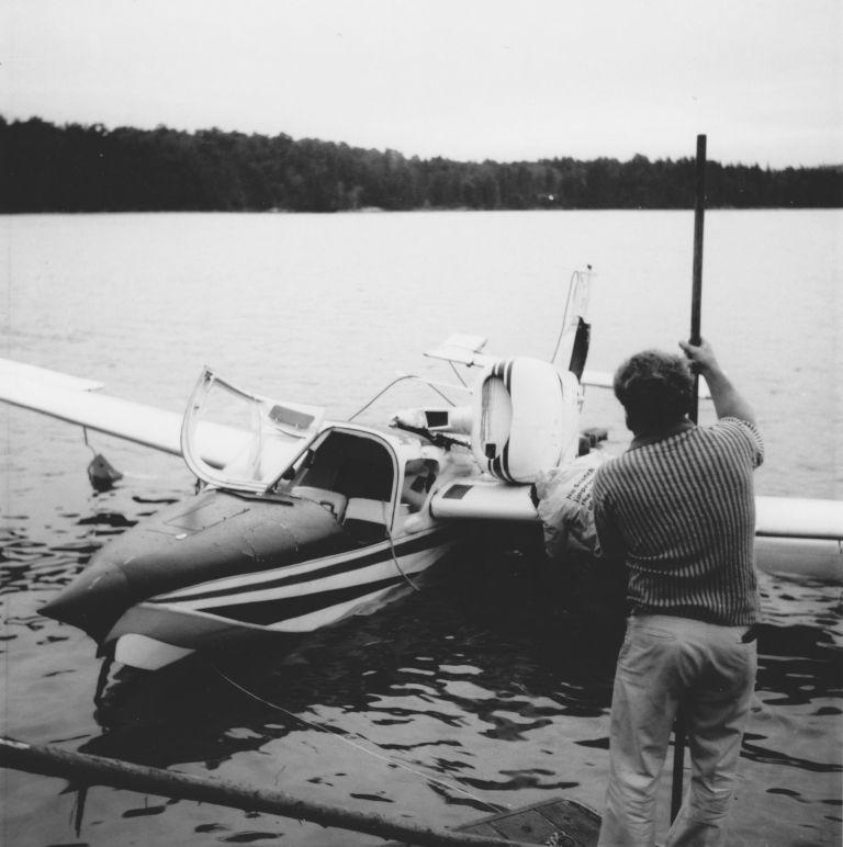
| Many of the cottagers and young people enjoyed examining the retrieved aircraft. Pictured here are Scott and Blake Hutcheson. (Margaret Thompson Clifford photo) | Aircraft righted and on the edge of Perry’s beach (Margaret Thompson Clifford photo) |
Sources:
Huntsville Forester, “Plane Crashes in Bella Lake,” August 17, 1972, p. 1.
Hutcheson, Bob (Muskoka Wood Manufacturing, Hutcheson Forest Industries, Bella Shores Road).
Mansell, W. D., and Carolyn Paterson, eds. Pioneer Glimpses from Sinclair Township, Muskoka (Peterborough: asiOtus Natural Heritage Consultants, Barbara Paterson Papers, 2015).