

An Imaginary Line
 |
|
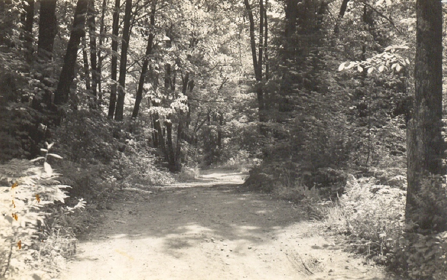
Downhill on the Billie Bear Road, 1957. The straight stretch to Brooks Lake Road echoes the old Bobcaygeon survey line. (Billie Bear Archive, Gertrude Davis Slide Collection)
|
From Muskoka Road 8 to the Brook’s Lake Road corner, Billie Bear Road follows an old path – a tiny piece of what, in the 1850s, was planned as a major “colonization” road to open up a part of the Ottawa-Huron Tract to settlement.
John McAree’s plan of 1876 for Sinclair featured a tempting imaginary line in the form of two rows of lots on the eastern edge of the township fronting on the surveyed line for the Bobcaygeon road, originally planned to connect Bobcaygeon, just north of Peterborough and Lindsay, with the proposed (but never completed) end of the Ottawa and Opeongo road at Lake Nipissing. The Sinclair portion of this road did not exist, of course, but, for early Sinclair settlers, choosing lots along the line’s phantom stretch – as a number did – would have seemed sensible. By 1876, however, it had long been abandoned by the government.
Impassable Terrain
The Bobcaygeon road had reached Minden by 1858, and reports from the Crown Lands agent in Bobcaygeon and surveyor James W. Bridgland indicate that this southern portion was relatively settled and at least passable by 1861. The northern section, however, was another story. The survey north of Minden to Lake Nipissing had been fraught with trouble from the start: rugged county, terrible weather, and death and illness from scurvy had plagued the crew. Although the road ostensibly reached the Oxtongue River in 1862, it was only passable as far as Cedar Narrows (present-day Dorset). The terrain to the north was such that Walter Beatty, estimating the cost of putting the road “into reasonable condition for travel,” recommended to the Commissioner of Crown Lands in 1864 that no further work be contemplated. Citing steep hills in particular, Beatty wrote, “My estimate for this portion is what is absolutely necessary to make the road passable [,] good it cannot be made without involving a thorough exploration of the lands adjoining.” Sinclair settlers travelling from Durham County, including Andrew Hart and his brothers, may indeed have taken the Bobcaygeon Road as far as they could, but the last stretch of the trip would almost certainly have followed the shores of Trading and Peninsula Lakes.
Bobcaygeon Line in Sinclair
The trail to the Antioch settlement skirted the west shore of Bella Lake, but another following the Bobcaygeon road allowance in Sinclair would have developed quickly as settlers took lots on each side of it through the 1880s and into the 1890s, especially after 1885, as the Sinclair and Finlayson Road (Muskoka Road 8), was extended through Sinclair into Finlayson Township.
The ribbon of lots along each side of the line, deviating from the usual grid of lots and concessions, was intended to give each settler a narrow front, and thus a shorter section of road to maintain. Settlers along settlement roads were assessed a certain number of days of statute labour to maintain and improve them, with local pathmasters appointed to coordinate the work.
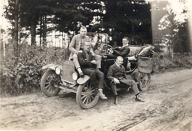
The track that became the “Billie Bear Road,” however stony, may have been drivable by 1919, when Pearson Hill and some of his friends from Newmarket visited Hillside and Billie Bear by automobile. For most guests, however, throughout the 1920s, the last part of the trip to Camp Billie Bear was by rowboat (and later launch) from Kells Landing on the southern tip of Rebecca Lake.
Sources:
Billie Bear Archive, Photo Collection; Document Collection.
Huntsville Forester, September 11, 1919, “Hillside,” p. 3.
Mansell, W. Dan, and Carolyn Paterson, eds., Pioneer Glimpses from Sinclair Township, Muskoka (Peterborough: asiOtus Natural Heritage Consultants, Barbara Paterson Papers, 2015).
Murray, Florence B., ed., Muskoka and Haliburton 1615-1875: A Collection of Documents (Toronto: University of Toronto Press, Champlain Society, 1963), “Introduction,” pp. lxxii-lxxiii; James W. Bridgland, “Report of Inspector of Surveys and Examination of Colonization Roads in Canada West,” 1861, pp. 206-207; Walter Beatty to the Commissioner of Crown Lands, Alexander Campbell, November 11, 1864, pp. 208-209.