


The Syndicate Road
 |
|
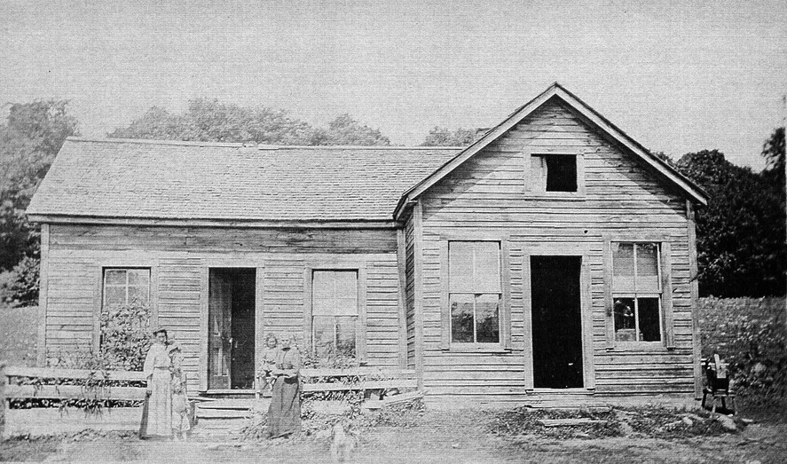
The Field family home at Field’s Corners as it appeared in 1929, with an addition to the original log building built in 1892 and covered with siding (Barbara Paterson Collection)
|
When townships were surveyed for settlement, the plans set aside road allowances – ideally to follow the lines between every second concession and every fifth lot. In Sinclair and most Muskoka townships, however, what made sense on the map rarely did so in the “curved space” of hills, swamps, rock, lakes, and streams. The settlers tasked with maintaining and building roads sometimes faced a difficult, if not impossible, job. Roads therefore meandered from the surveyed lines, following the easiest path through rugged terrain.
The Sinclair or Syndicate Road – now Limberlost or Muskoka Road 8 – was begun by settlers before the township was surveyed. Settlers Robert Walker and Henry Field had opened up, in stages, a track as far as their own lots in 1876 and 1878 respectively. Further official work on the Sinclair Road, contracted that year, conformed to the roughed-out track as far as Field’s.
Across Sinclair into Finlayson
What became known as the “Old” Sinclair Road continued north at the Field homestead, roughly between Lots 15 and 16. In 1879, settlers who had taken up lots to the east petitioned for government assistance to extend a road along the proposed alignment between Concessions 4 and 5, across the Bobcaygeon line at the eastern edge of the township.
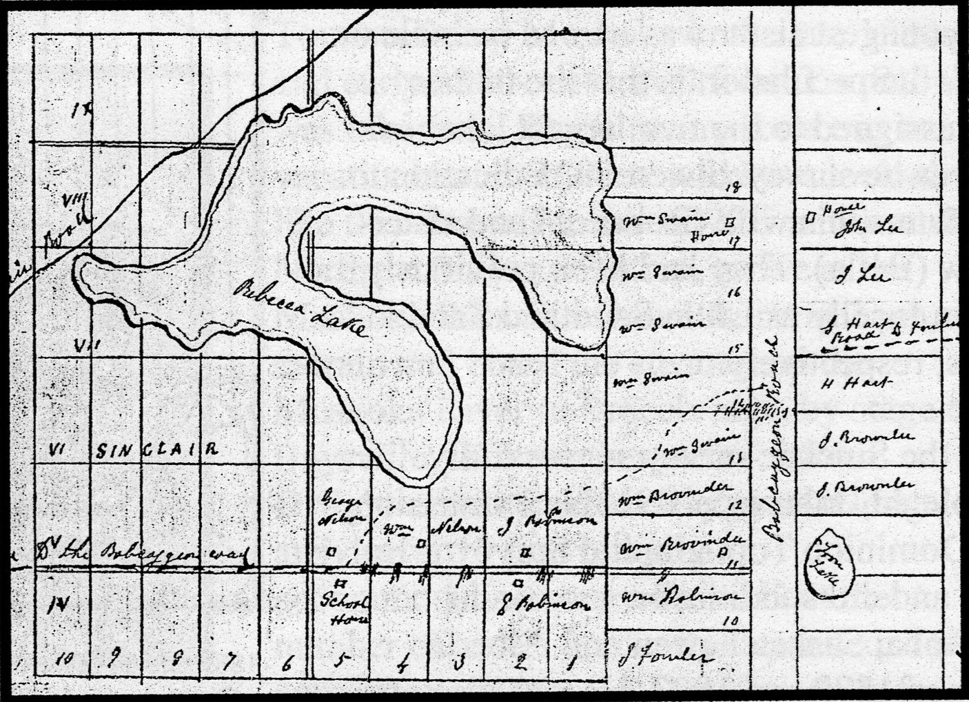 |
This sketch by road inspector D. M. Card shows, with the dotted line, the realignment of the Sinclair-Finlayson Road to avoid steep terrain along the line between Concessions 4 and 5. (Ontario Archives RG 52-1 B404629 1885 #2284) | |
The “Sinclair-Finlayson” road wandered from the surveyed line at several places, but along the concession line at Lot 5, the settlers reached an impasse. It is likely that there was some dispute as to where the road should go to avoid the steep hills, as in 1885 the road inspector was called in to investigate. The inspector, D. M. Card, found the concession line “totally unfit” for a road: “There are four or five heavy hills, and three what may be fairly called mountains.” Card was able to negotiate a route that cut northeast through the middle of lots occupied by William Nelson, John Robinson, and William Swain, crossing the Bobcaygeon line at Lots 14 and 15, Concessions A and B.
By 1888, when post office inspector Daniel Spry was adjudicating the second location of the Antioch post office, the road had been extended at least as far as Dotty (Long) and Oxbow Lakes, where William Hood had a general store. Provincial surveyors set out an alignment to continue the road into the new Algonquin Park beginning in 1894, but it was never used, as the Ottawa, Arnprior and Parry Sound Railway opened through the park three years later.
The Limberlost Road
While it gave settlers access to their lots in the interior of the township, “road” was certainly a euphemism for the track that existed even into the new century. Fishing and hunting parties cut trails from it to their camps; by the 1920s, with the popularity of motor car travel, tourist homes and lodges began to develop on the smaller, remote lakes off the Sinclair Road. Oxbow Lodge on Oxbow Lake, Royal Oak Lodge (originally the Walker House), and Limberlost on Solitaire (Clear) Lake all opened during the 1920s; Tynoka on Bella Lake and Fieldale on Rebecca Lake soon followed. Limberlost, probably the most widely known destination served by the Sinclair Road, gave the road its current name.
Into Camps and Cottages
The journey into camp or lodge in the 1920s and 1930s was a significant part of the adventure. One trip taken by William Mansell from the dock at Grassmere to Sunset Farm on Rebecca Lake in the 1930s, Dan Mansell writes, took an entire morning, “over tracks that were sometimes on rock outcrops, and sometimes in swamp mud.”
Even by the 1940s, guests heading to Billie Bear from Huntsville tensed for “that traumatic ride into camp.” Edgar Brook, husband of proprietor Mabel Book and builder of most of the small roads into camps and lodges, had little sympathy for tenderfeet from the city. “Anybody that can drive,” he said, “can drive that road.”
 |
 |
|
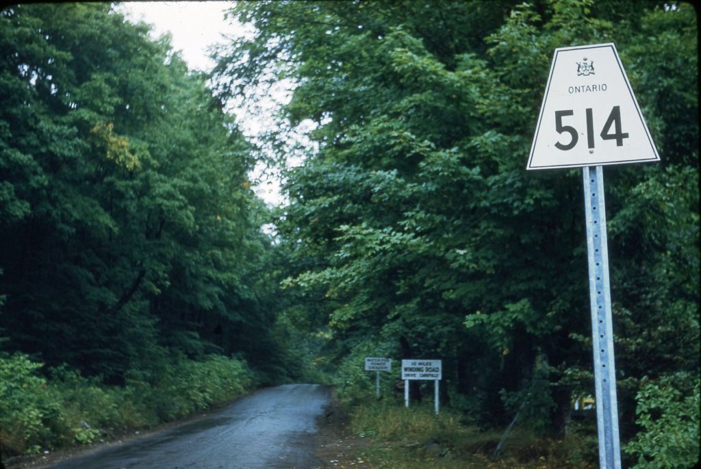
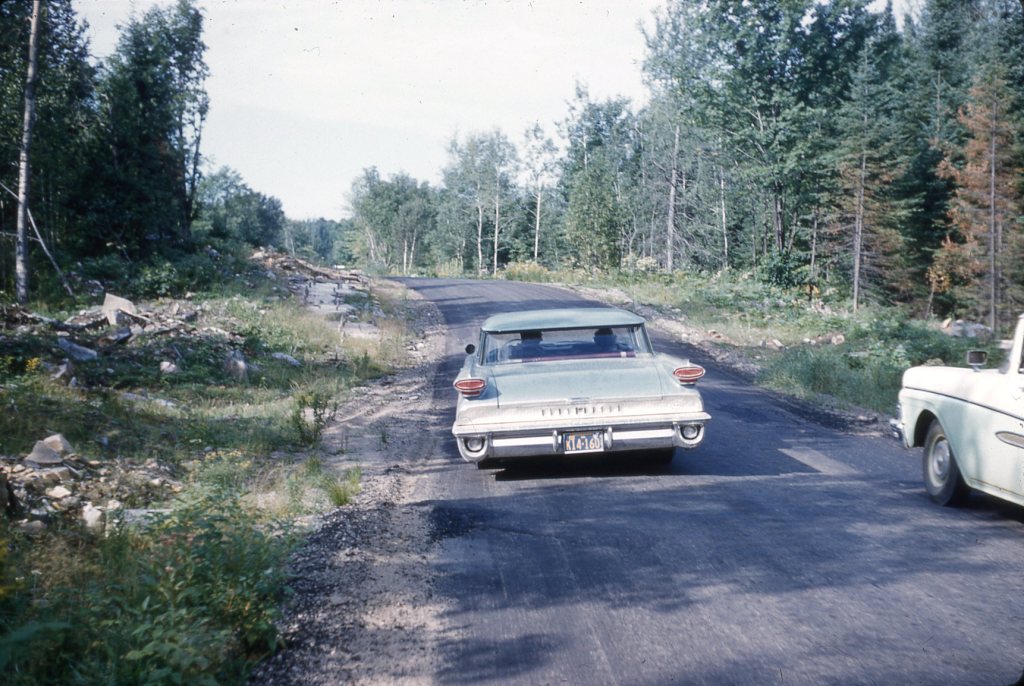
| Entrance to Highway 514 from Highway 60 in 1958. The signs warn of winding road for 10 miles and “watch for power grader.” (Billie Bear Photo Archive, Gertrude Davis Slide Collection) | Billie Bear guests’ cars (Livingston and Davis) on Highway 514 in September 1962. Road work may have been planned, judging by the clear cut along the roadsides. (Billie Bear Photo Archive, Gertrude Davis Slide Collection) |
For some, however, the trip was entirely outside any previous experience. The province had assumed upkeep of the Syndicate Road in 1942, to serve the Norwegian Air Force camp, Vesle Skaugum, at Interlaken (Oxbow Lake), but it remained remote. Wendy Kimmel recalls her mother’s first visit to the Mansell cottages:
In 1945 the war in Europe was over. My Dad, who was in Holland, volunteered for the Pacific, had been shipped back across the Atlantic and was in-transit across Canada by train when the bomb was dropped on Nagasaki. He arrived in Toronto for leave when the second bomb was dropped and the war was over. He immediately registered at the University of Toronto and then invited his girlfriend, who wasn’t quite 19 years old, up to the cottage for the weekend. My Mom, very much the city girl, wondered what she had gotten herself into as they drove in Hwy 514, on a narrow dirt road, up and down over the rocky hills, around sharp corners, in pitch dark, to a place she had never been before. Of course she took to the cottage like an old friend.
Marcia Julian’s parents spent part of their honeymoon at the Hutcheson cottage, “coming in over 514 and a newly built Hutcheson Road. Dad grew up on a farm in Cornwall, UK, and knew nothing about swimming, cutting wood, boating, campfires, marshmallows… He had to learn fast.” In 1956, the Limberlost Road became secondary Highway 514, and over the years parts were graded, widened, straightened, and eventually paved. Jurisdiction was transferred to the District Municipality of Muskoka when it was formed in 1971.
Sources:
Billie Bear Documents Archive, Betty Schielke interview with Leo Serroul, June 1994; Gerry Livingston letter to Barbara Paterson, August 1982.
Huntsville Forester, “Highway 514 Re-surfaced,” August 27, 1959.
Julian, Marcia, personal communication, April 4, 2019.
Kimmel, Wendy, personal communication, April 4, 2019.
Mansell, W. Dan, Sunset Farm (Peterborough: asiOtus Natural Heritage Consultants, Barbara Paterson Papers and Mansell Heritage Series, 2012).
Mansell, W. Dan, and Carolyn Paterson, eds., Pioneer Glimpses from Sinclair Township, Muskoka (Peterborough: asiOtus Natural Heritage Consultants, Barbara Paterson Papers, 2015).
Miller, Marilyn G. (with the assistance of Joe Bucovetsky and Elizabeth Sisam), Straight Lines in Curved Space: Colonization Roads in Eastern Ontario (Toronto: Ontario Ministry of Culture and Recreation, Historical Planning and Research Branch, 1978).
Pryke, Susan, Huntsville: With Spirit and Resolve (Huntsville: Fox Meadow Creations, 2000).
“Secondary Highway 514 (#1),” The King’s Highway: The History of Ontario’s King’s Highways, www.thekingshighway.ca/Highway514.htm